Subscribe to our e-newsletter!
If you are looking for Hungarian events, great recipes, cultural connections, and encouragement as you celebrate your Hungarian heritage, we are here to help! We will never share or sell your data.
Trouble ordering? Call 1-800-786-7851

If you are looking for Hungarian events, great recipes, cultural connections, and encouragement as you celebrate your Hungarian heritage, we are here to help! We will never share or sell your data.
$70.00
Shipping on this product is included!
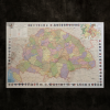
We are excited to be able to offer this full color circa 1910 Laminated Map of Hungary now with the boundary lines of current Hungary outlined and county crests around the edges. This large map is approximately 24″ x 35″. A great conversation piece. This is a wonderful item for classroom teaching, genealogists, Hungarian history buffs, and Hungarian clubs. Great for den or office!
This map is a very popular display piece at the events we attend. There are many small towns and villages noted as well as all the old county boundaries (megye – county). Everything outside of the current borderline of Hungary is listed with its Hungarian name as this is a map from that time frame.
We found a great map frame at JOANN Fabrics and it was 40% off so we picked it up for less than $25. It is nearly a perfect fit (it is 24″ x 36″) and very easy to work with!
Out of stock
Laminated Map of Hungary
NEW! Now with the current boundaries of the Hungary outlined!
We are excited to be able to offer this full color circa 1910 Laminated Map of Hungary with the boundary lines of Hungary outlined and county crests around the edges. This large map is approximately 24″ x 35″. A great conversation piece. This is a wonderful item for classroom teaching, genealogists, Hungarian history buffs, and Hungarian clubs. Great for den or office!
Map ships separately if ordered with other items.
If you have trouble ordering from the website please call 1-800-786-7851 or email Liz@MagyarMarketing.com
You must be logged in to post a review.
Accessories
Accessories
Accessories
Accessories
Accessories
Accessories
Accessories
Accessories
Accessories
Accessories
Accessories

Out of stock
Reviews
There are no reviews yet.